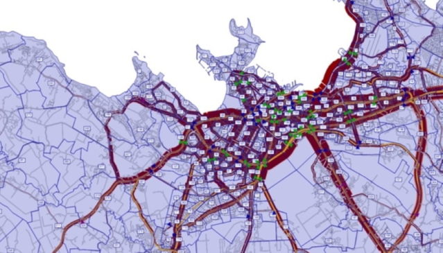
Tallinn is introducing a digital transport model to enable it to forecast and analyse citizens’ mobility needs and inform decision-making when it comes to the city’s transport systems and urban space.
Developed by the Tallinn Transport Authority, the tool brings together all available data to help the city better understand how and when people move around the Estonian capital.
Updated data
The transport model includes constantly updated data on 130,000 different road sections in the capital and takes into account the movement of cars, public transport, lorries and pedestrians.
The software model is based on applications supplied by the German software and consulting company PTV Group, which are also used in other major European cities. The model includes all the mobility data available to the city, including an analysis of the results of social surveys carried out in the city over the last five years, the road network and traffic frequencies.
It can distinguish 12 different types of road users or user groups, including students, workers and pensioners with and without a car, both from Tallinn and elsewhere in Harju County. It also takes into account complex movement patterns. For example, whether a person takes children to kindergarten on the way to work or visits a store.
The model will be used in Tallinn’s transport planning, including traffic management and the renewal of the public transport route network, as well as in urban planning. Based on the transport model, it is possible to forecast the load on the city’s transport infrastructure, quickly assess the need to develop public transport systems and the impact of new development areas on transport infrastructure in general.
For example, the model will help to identify when and why congestion occurs in a specific place or what reorganisation is needed to reduce the inconvenience caused by road repairs. It will also allow the city authorities to play through and analyse scenarios when transport planning.
“It makes it possible to anticipate transport problems and understand their causes, and to make decisions that support the overall development of the city and to anticipate the effects of decisions to be taken,” said Andrei Novikov, deputy mayor of Tallinn. “It is not an instrument for a specific project, but a permanent internal analysis tool that can be used to assess the feasibility and impact of major infrastructure investments on traffic.”
He added: “Among other things, we can assess the different needs of the people in each region. The traffic simulations used in the model can, for example, make better decisions about what the capacity needs of one or the other should be today, or, for example, assess decisions to upgrade the city’s public transport network.”
Source: smartcitiesworld.net
Source: IOT NETWORK NEWS


